BryteCube.
Komplexe Herausforderungen brauchen einfache IT-Lösungen.

Die KI für vernetzte Informationssysteme - auf Knopfdruck.
BryteCube ist eine wissensbasierte künstliche Intelligenz (KI), die auf Knopfdruck vernetzte geografische Informations- und Managementsysteme nach individuellen Anforderungen generiert. Was wie Zauberei klingt, ist das Ergebnis von 30 Jahren Forschung und praktischer Anwendung und wird heute von öffentlichen Verwaltungen und Infrastrukturbetreibern für ihre Schlüsselprozesse genutzt.
Die Anwendungen von BryteCube stehen Individualentwicklungen in nichts nach, was Funktionalität, Qualität und Sicherheit betrifft. Im Gegenteil! Häufig benötigte Lösungsmuster sind ohne Programmierung sofort einsatzbereit, einschliesslich Projekt- und Prozessmanagement, Geodaten- und Messdatenerfassung, E-Mail-Benachrichtigungen, Dokumentenmanagement und Inventarverwaltung mit Lifecycle Management.
Ohne Risiko und zu einem Bruchteil der Zeit und Kosten realisieren Sie Ihre massgeschneiderte Informations-, Zusammenarbeits- und Managementlösung. Alle Funktionen von BryteCube sind praxisbewährt. Ihre Plattform organisiert und verknüpft Ihre Daten und legt sie gleich im richtigen Kontext ab. So finden Sie und alle weiteren Beteiligten in jeder Situation zielgenau die benötigten Informationen.
Für geografisch ausgerichtete Aufgaben bietet BryteCube ein digitales Spielfeld, auf dem alle Akteure ihre Bedürfnisse selbst anmelden und ihre Aufgaben koordinieren können. Die Plattform kann eigenständig intelligente Vorschläge machen, um Massnahmen zu koordinieren und Projekte zu bündeln. Wie viel Zeit und Kosten können Sie dadurch sparen? So können Sie und Ihr Team sich auf die wesentlichen Aufgaben konzentrieren und Ihre Ziele erfolgreich erreichen.

BryteCube liefert fertige Lösungsmuster, angepasst an die Anforderungen Ihrer Organisation.
BryteCube.
Komplexe Herausforderungen brauchen einfache IT-Lösungen.

Für zeitgemässes Umwelt- und Infrastruktur-Management - effektiv und nachhaltig
Die Natur und unsere Umwelt sind unbezahlbar. Unsere Infrastrukturen sind das Werk von mehreren Generationen. Diese Werte zu erhalten und weiterzuentwickeln ist eine der grossen Herausforderungen unserer Zeit, der Sie sich mit Engagement stellen.
Sie sind ständig mit Ansprüchen an den öffentlichen Raum konfrontiert, die sich nur schwer unter einen Hut bringen lassen. Der Raum ist begrenzt, die Kommunikation zwischen den verschiedenen Interessengruppen ist nicht optimal und für viele Massnahmen fehlt schlichtweg das Geld.
Alles unter Kontrolle mit BryteCube - Die relevanten Informationen vernetzt
Wer im geografischen Raum tätig ist, soll alle relevanten Informationen vernetzt verfügbar haben, jederzeit, überall und so einfach wie möglich. Dieses Ziel verfolgen wir von Condesys Consulting seit über zwanzig Jahren.
Mit BryteCube haben wir für unsere Kunden im Umwelt- und Infrastrukturmanagement eine Informationsplattform geschaffen und mit wissensbasierter künstlicher Intelligenz ausgestattet. Damit richten Sie in kürzester Zeit Ihre eigene Web-Anwendung mit Geodatenbank ein, die Sie und ihr Team sofort ohne Programmierung nutzen können.
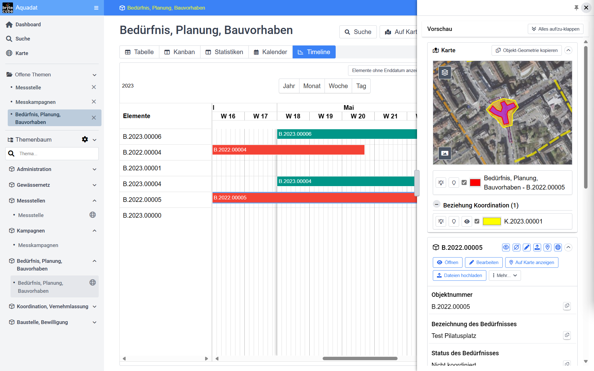
Alle Massnahmen im Blick mit zeitlicher und geografischer Koordination auf BryteCube.
Sie verwalten auf BryteCube nach ihren Anforderungen und auf einheitliche Weise Ihre Inventare und Anlagen mit den zugehörigen Prozessen und Projekten. Sie vernetzen diese mit Mess- und Geodaten sowie Fotos und Dokumenten einschliesslich des E-Mail-Verkehrs.
Die Anwendungen von BryteCube reichen von der Vollzugsplattform für die vielen Aufgaben aus der Umweltschutzgesetzgebung über die Jagdverwaltung, die Netzplanung und Baukoordination bis zum Management der Instandhaltung von Hochleistungsstrassen.
Wir haben mit BryteCube die Einstiegshürden in Geodatenbanken und das vernetzte Lifecycle Management auf ein Minimum gesenkt. Das Wissen zum Aufbau einer Datenbank mit Geodaten steht Ihnen auf Knopfdruck zur Verfügung. Darauf können Sie sich verlassen, denn schliesslich sind wir die weltweiten Pioniere in der Geodatenbanktechnologie nach OpenGIS, haben Datenmodellierung an mehreren Hochschulen unterrichtet und an grossen Projekten über Jahrzehnte verfeinert.
Aus Ihren Anforderungsspezifikationen werden Datenbankstrukturen, Web-Services und Web-Anwendungen automatisch generiert. Ohne Wartezeit für eine Individualentwicklung legen Sie und Ihr Team mit BryteCube in wenigen Tagen mit Ihrer eigenen Anwendung los.
Und weil die Fachkräfte für die Individualentwicklung in BryteCube «eingebaut» sind, sind Sie in der Lage, Ihre Informations- und Koordinationsplattform für Ihre wachsenden Anforderungen Schritt für Schritt selbst auszubauen.
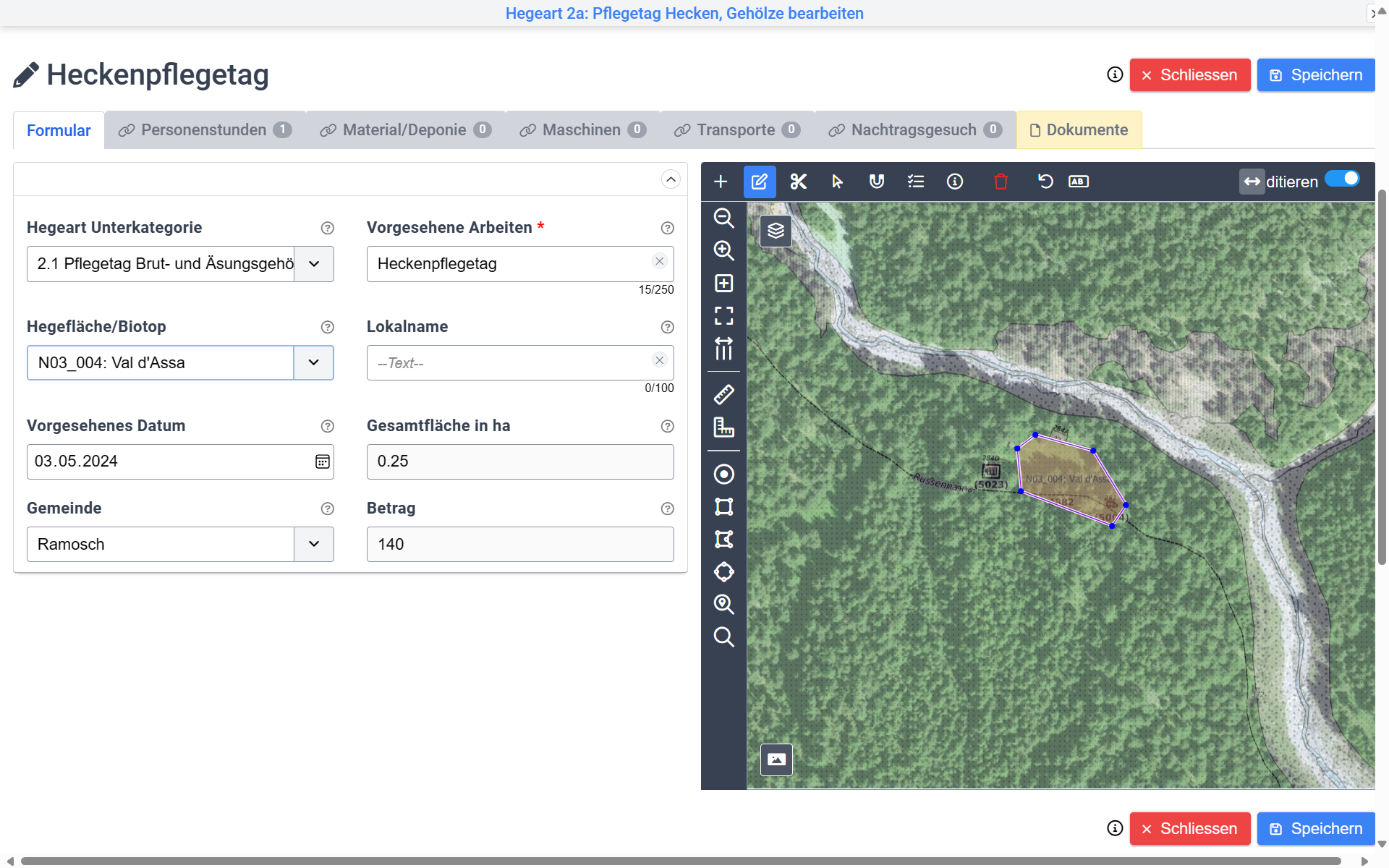
Geodatenerfassung in der BryteCube-Web-Anwendung durch die Leute vor Ort.
BryteCube im Einsatz
Der Schlüssel zum Erfolg

Koordination im öffentlichen Raum
BryteCube und seine Vorläufer sind schon über zwei Jahrzehnte die bewährte geografische Koordinationsanwendung im Internet. Hier zeichnen alle Beteiligten ihre Projekte auf der Karte ein, so dass alle wissen, wer, wann, wo, was geplant hat. Projektkosteneinsparungen von 10 - 25% sind üblich. Begleitende Massnahmen für die Schaffung einer barrierefreien Stadt, für die Entsiegelung zur Beseitigung von Hitzeinseln und zur Schaffung einer Schwammstadt sowie zur Förderung der Biodiversität laufen systematisch bei allen Projekten praktisch ohne Mehrkosten mit.
Wie die grössten Schweizer Städte und Kantone kann auch Ihre Organisation mit BryteCube die gesamte Strasseninfrastruktur mit Lichtsignalanlagen, Brücken und weiteren Kunstbauten, Entwässerungen, Grünflächen, Schutzbauten, Leitungsnetzen usw. verwalten, den Zustand erfassen, Unterhalts- und Instandhaltungsmassnahmen planen sowie Neubau- und Sanierungsprojekte mit allen Beteiligten koordinieren.
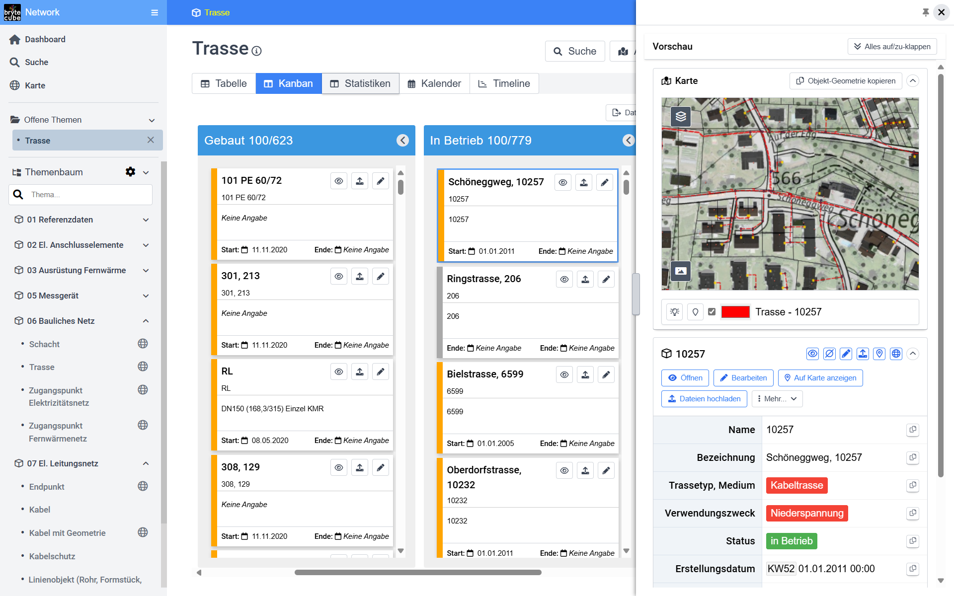
Alles im Griff mit dem Kanban-Aufgabenmanagement von BryteCube.
Wählen Sie aus Fachdatenmodellen für Elektrizitäts-, Fernwärme-, Glasfaser-, Kanalisations- und Entwässerungs-Netze usw. Ihre aus und passen Sie diese an die Bedürfnisse Ihres Werkes an. Die Projekt-, Betriebs- und Instandhaltungs-Module von BryteCube sorgen für eine einheitliche Vorgehensweise in Ihrer gesamten Organisation und ermöglichen es Ihnen, ressourcensparende und nachhaltige Koordinations- und Lifecycle-Management-Prozesse einzuführen. Effiziente Datenmigrations- und -synchronisierungsprozesse helfen Ihnen zudem, die bestehenden Daten rasch und qualitätsgesichert auf Ihre BryteCube-Datenplattform zu bringen.
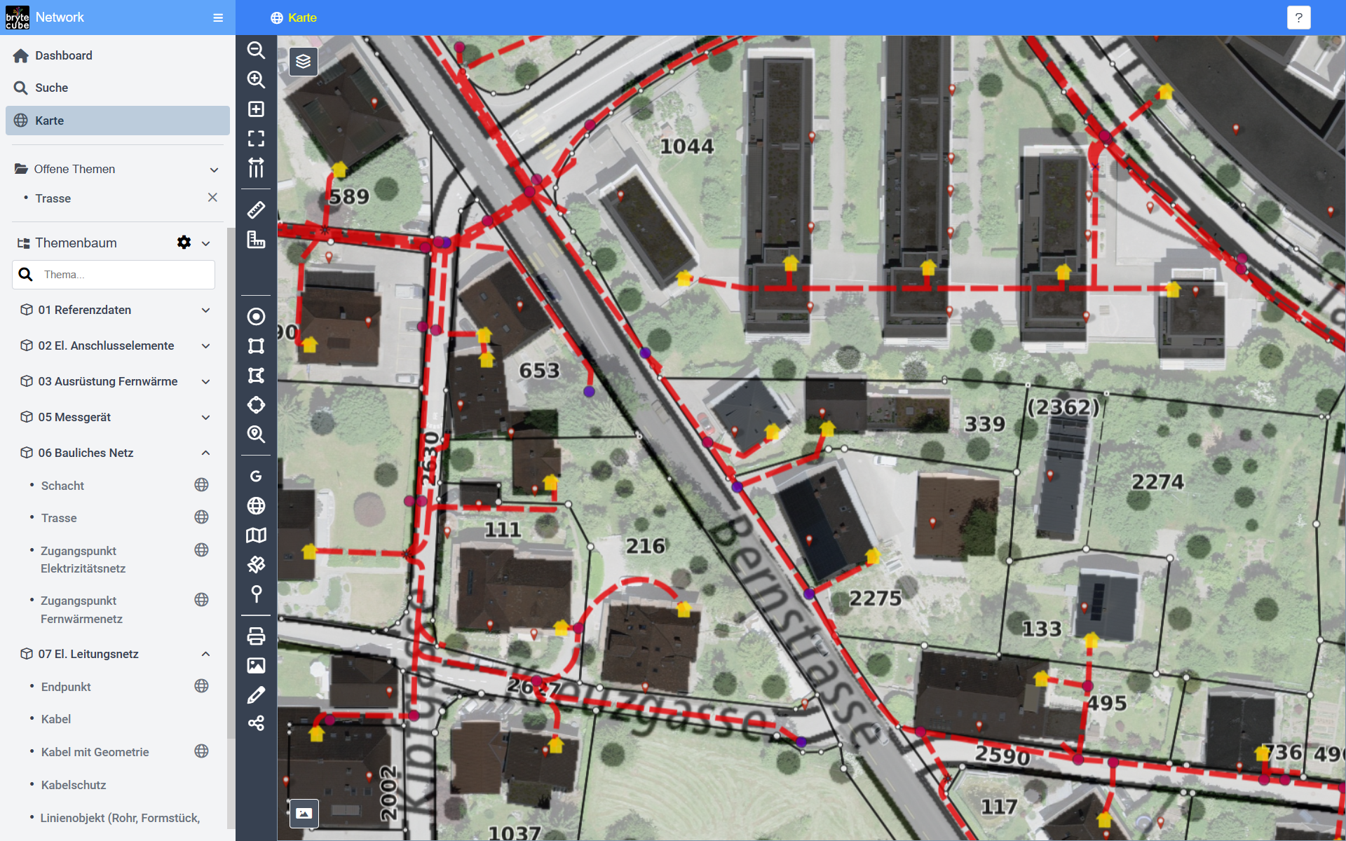
Ob Glasfaser, Elektrizität oder Fernwärme, mit BryteCube ist Ihr Fachdatenmodell sofort einsatzbereit.
BryteCube ist in wenigen Tagen betriebsbereit als Ihre Plattform zum Austausch von Projektinformationen, für die Bildung von koordinierten Projekten, für die Vernehmlassung zur Einholung von Stellungnahmen aller Beteiligten und Betroffenen und zur Auskunft über bevorstehende und laufende Baustellen. BryteCube ist Ihr digitales Spielfeld für die systematischen Koordination im öffentlichen Raum. Gewerbe und Bevölkerung danken Ihnen jede Baustelle, die vermieden werden kann.

Vernetzte Plattform für den Vollzug der Gesetzgebung zu Umwelt, Wald und Landwirtschaft
Umweltbehörden in der Schweiz und in Liechtenstein bauen seit Jahren auf BryteCube. Sie erfassen systematisch alle umweltrelevanten Anlagen im Rahmen von Bewilligungsverfahren. Die Daten für die Umweltbeobachtung mit Inventaren, Kartierungen und Messstellen stehen auf ihrer BryteCube Plattform bereit. Laufend fliessen aktuelle Messdaten in die Datenbank, die den Zustand der Umwelt, die Auswirkungen unserer Tätigkeiten und die Wirkung von Schutzmassnahmen dokumentieren.
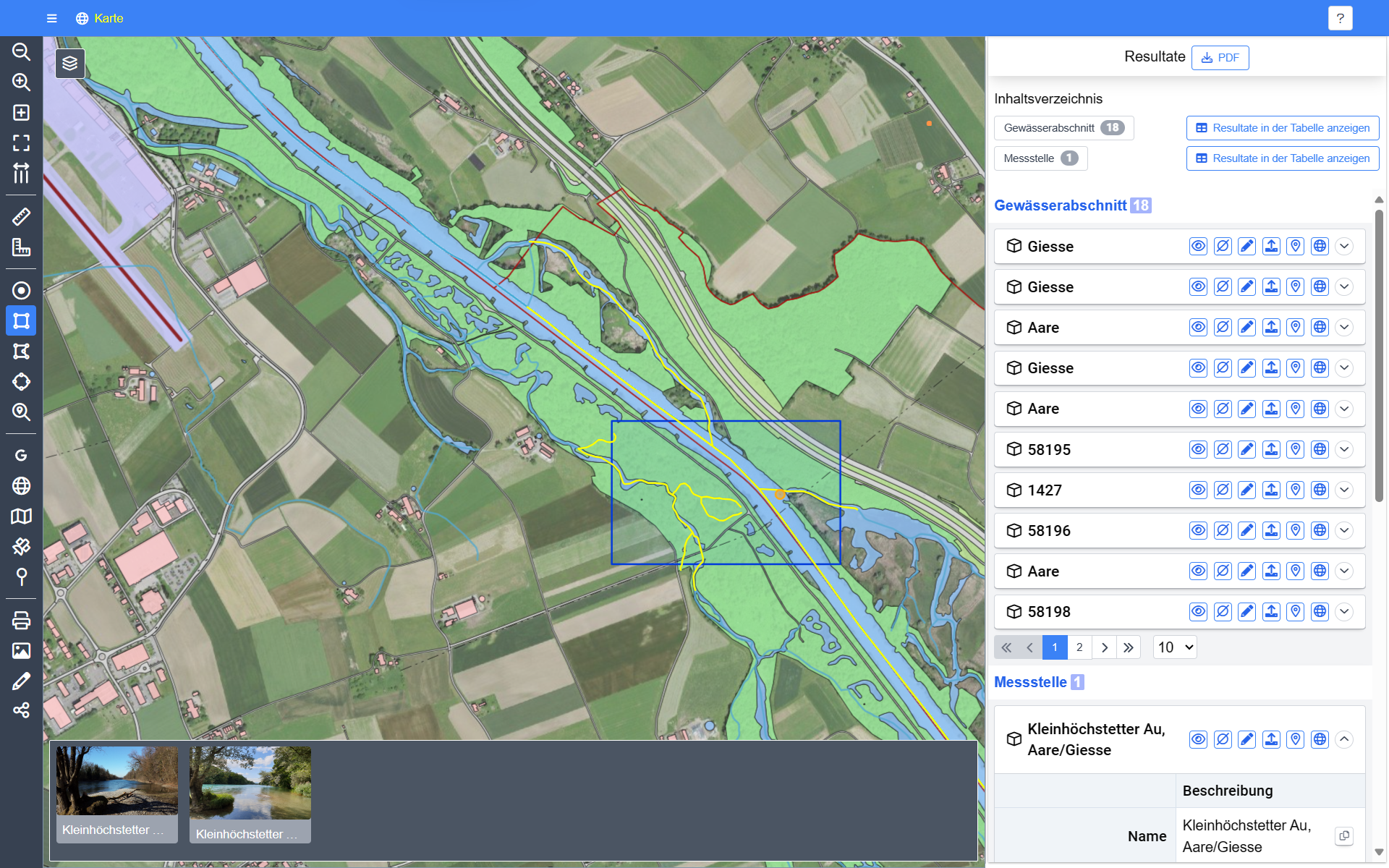
Eine räumliche Abfrage in der BryteCube-Datenbank liefert sofort alle Messstellen und Inventare zur Weiterverarbeitung.
Alle Gesuche werden in einem einheitlichen Prozess zwischen den Fachabteilungen koordiniert. Auf aktuellster Datengrundlage wird die Einhaltung von Umweltschutzvorgaben geprüft, dank der integrierten Geodatenverwaltung weitgehend automatisiert. Das spart Zeit und gibt zufriedene Gesuchsteller. Bewilligungsdokumente und die zugehörigen Rechnungen erstellen sie schliesslich auf Knopfdruck.
Die einfachen Web-Anwendungen von BryteCube stehen auch Ihnen sofort zur Verfügung mit GIS-Funktionen, Messdatenverwaltung, Foto-, Dokumenten- und E-Mail-Management, Projekt- und Aufgabenmanagement und vielem anderem mehr. Nie mehr nach Unterlagen suchen! Mit BryteCube stehen alle Ihre Grundlagendaten und Geschäftsinformationen sofort im Web-Browser zur Bearbeitung bereit. Ob mobil oder im Büro, alle Beteiligten erfassen neue Informationen rasch im richtigen Zusammenhang. So vereinfachen Sie und Ihr Team die Kommunikation und beschleunigen die Prozesse und Entscheidungen.
Wenn Ihre GIS- und Datenbankanwendungen in die Jahre gekommen sind und ihren Zweck nur noch begrenzt erfüllen. Wenn unzählige Excel-, Access- und Shape-Dateien auf Ihren Dateiablagen herumgeistern. Dann gewinnen Sie mit BryteCube Ihre Handlungsfähigkeit zurück.
In wenigen Schritten bringen Sie Ihre Inventare und Vollzugsprozesse auf eine geordnete Datenplattform und verlinken sie mit den dazugehörenden Mess- und Geodaten sowie den Dokumenten, Fotos und dem gesamten E-Mail-Verkehr.
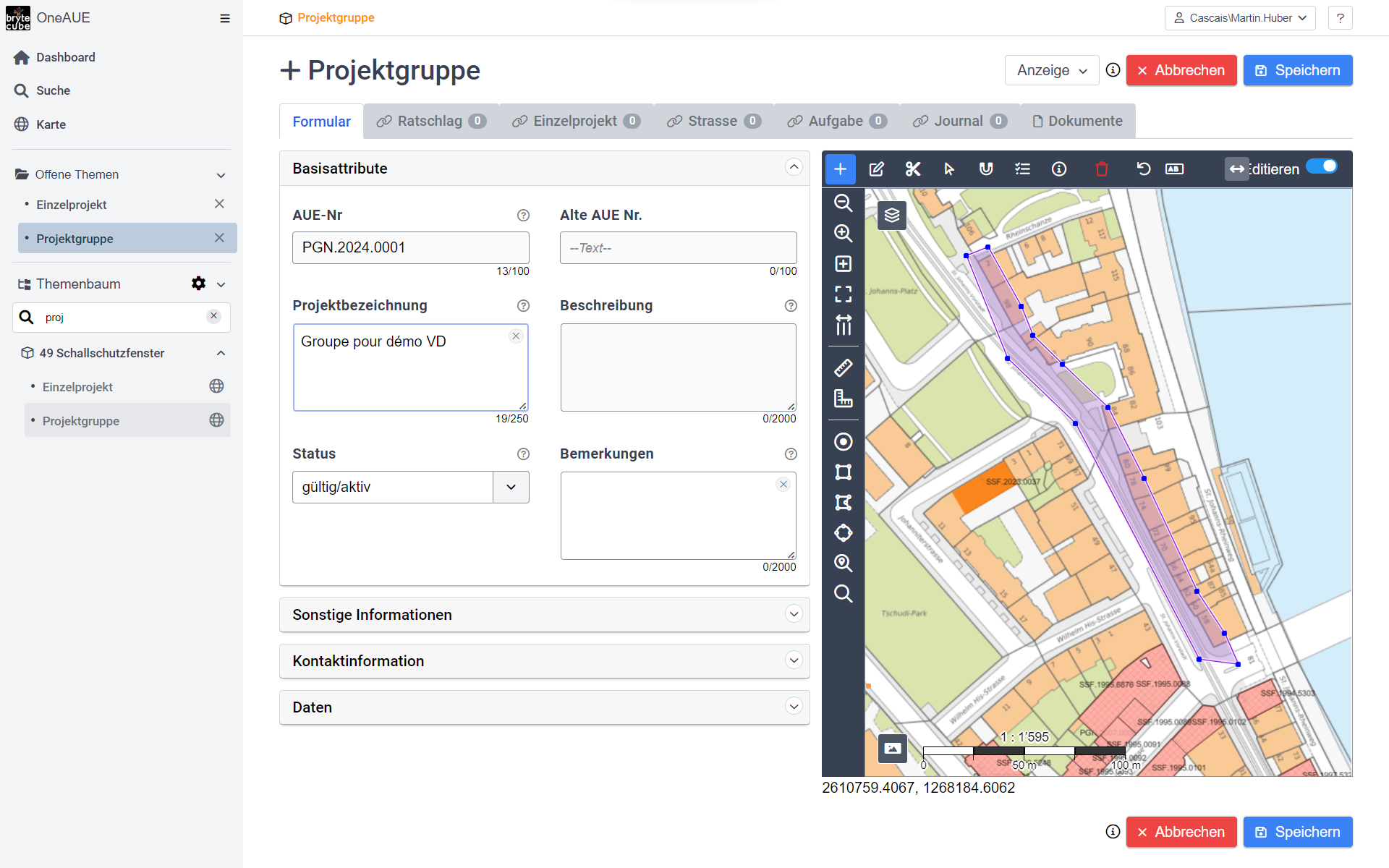
Mit BryteCube benötigen Sie keine komplizierte GIS-Software mehr. Alle Daten können direkt im Web-Browser editiert werden. Abfragen und Auswertungen erfolgen direkt in der Datenbank.
Ohne Programmierung erstellen Sie mit BryteCube genau die Anwendungen, die Ihre spezifischen Anforderungen erfüllen. Fachdatenmodelle übernehmen Sie auf Knopfdruck. So optimieren Sie Ihre Prozesse und reduzieren nachhaltig Ihre Kosten.
Worauf warten Sie?
Holen Sie sich die Zukunft in Ihr Geschäft!

Unser Versprechen an Sie:
Ein lauffähiger Entwurf Ihrer neuen Informations- und Koordinationsplattform nach unserem Erstgespräch
Sie haben wichtige Aufgaben zu erledigen und Sie haben sich zum Ziel gesetzt, Dinge besser zu machen. Sie haben sich für eine Sache entschieden, die Sie interessiert und für die Sie bereit sind, neue Wege zu gehen. Welches ist Ihre dringendste Herausforderung? Mit BryteCube managen Sie selbst Ihre komplexesten Daten und Prozesse mit Leichtigkeit.
Mit dem Einsatz von BryteCube als Ihre integrierte Informationsplattform reduzieren Sie substanziell das Risiko einer langwierigen Individualprogrammierung. In wenigen Tagen sind Sie und Ihr Team betriebsbereit. Neue Anforderungen setzen Sie rasch, kostengünstig und nach Ihren spezifischen Anforderungen jederzeit um. Die typischen BryteCube-Kunden – vorwiegend Umweltbehörden und Infrastrukturbetreiber – starten mit wenigen dringenden Datensätzen und Prozessen. Nach kurzer Zeit haben sie fünfzig, hundert und mehr Themen vernetzt aus ihren Datenbeständen übernommen und einheitlich in der gesamten Organisation bereitgestellt.

Bewährte Lösungsmuster auf Knopfdruck beschleunigen den Aufbau Ihrer neuen Informations- und Koordinationsplattform auf BryteCube und reduzieren Ihre Risiken.
BryteCube hilft Ihnen, auf organische Weise Ihre Prozesse und Ihre Organisation auf ein zeitgemässes und nachhaltiges Umwelt- und Infrastruktur-Management umzustellen. Damit sie den heutigen und zukünftigen Herausforderungen gewachsen sind.
Teilen Sie uns Ihre dringendsten Herausforderungen mit. Nach unserem Erstgespräch zeigen wir Ihnen bereits eine lauffähige Skizze Ihrer neuen Informations- und Koordinationsplattform auf BryteCube. Kontaktieren Sie uns unverbindlich unter info@condesys.com.

Hinter BryteCube steht eine skalierbare IT-Infrastruktur, magisch gesteuert durch wissensbasierte künstliche Intelligenz.
20 Jahre Condesys Consulting
2004 - 2024
Die innovativen Lösungen von Condesys Consulting prägen nachhaltig, wie Informationssysteme mit geografischen Daten aufgebaut und genutzt werden. Mit BryteCube sind die Hürden für den Einsatz eigener kooperativer Informationslösungen massiv gesunken. Am Geburttagsfest blicken wir zurück auf unsere zukunftsweisenden Innovationen der letzten 20 Jahre und schauen voraus, wie unsere Kunden mit BryteCube ihre Visionen souverän umsetzen, um ihre heutigen und zukünftigen Herausforderungen zu meistern.

"I Have Seen the Future"
2004, nach dem Verkauf seines EPFL-Start-ups GeoTask AG, gründete Dr. Martin Huber die Condesys Consulting GmbH in Basel.
Die GeoTask AG hatte 1998 die Geodatenbank-Technologie einen entscheidenden Schritt vorwärtsgebracht durch die weltweit erste Implementierung des OpenGIS-Standards für SQL. Condesys Consulting erschloss nun die immensen Möglichkeiten der standardisierten Geodatenbereitstellung für die Praxis. Die ersten 10 Jahre von Condesys Consulting waren geprägt durch den Entwurf und die Umsetzung von Lösungsarchitekturen für teilweise gigantische Infrastruktur- und Umwelt-Management-Systeme, darunter das System für das Mangement des gesamten physischen Netzes der Swisscom sowie deren System für das agile Glasfaser-Rollout, zudem die Architektur des Strasseninformationssystems Nordrhein-Westfalen mit Integration von 14 Fachsystemen für eine Organisation mit 6000 Mitarbeitenden (Video: NWSIB kurz erklärt).
Die zweite Dekade wurde der Entwicklung von BryteCube gewidmet. BryteCube ist eine wissensbasierte künstliche Intelligenz (KI), die auch mittlere und kleine Organisationen befähigt, ein umfassend vernetztes Informationssystem mit integrierter Geodatenverwaltung nach eigenen Bedürfnissen einzurichten. BryteCube wird seit Jahren erfolgreich im Umwelt- und Infrastrukturmanagement eingesetzt.
Mit BryteCube werden Projekte und Massnahmen im geografischen Raum organisiert und koordiniert mit Fokus auf den Lebenszyklus der Infrastruktur und die Werterhaltung (z.B. Planungs- und Baukoordination der Stadt Bern mit 40 beteiligten Bedarfsstellen und die Instandhaltung der Nationalstrassen am Gotthard). BryteCube eignet sich besonders, wenn komplexe Prozesse mit vielen Beteiligten über Organisationsgrenzen hinweg abgewickelt werden müssen (z.B. Organisation der Hege der Wildtierhabitate des Kantons Graubünden oder die Plattform für den Vollzug der Umweltschutzgesetzgebung des Kantons Basel-Stadt).
BryteCube ist auch die Plattform für die Konsolidierung heterogener Datenbestände mit Raum- und Zeitbezug. BryteCube befähigt die Fachpersonen, die Daten für ihre komplexen konzeptionellen und betrieblichen Aufgaben selbst zu bewirtschaften, ohne Umweg über eine GIS- oder IT-Abteilung (z.B. Umweltdatenkataster Liechtenstein und Geodatenmanagement von Grün Stadt Zürich).
Mit dem internationalen RemiPCA SAFE Network, das unsere Co-Geschäftsführerin Dr. Andrea Anna Melber mit inzwischen 40 Spitälern aufgebaut hat, beweist BryteCube seine universelle Einsatzfähigkeit für die digitale Zusammenarbeit über Organisationsgrenzen hinweg mit komplexen Daten- und Prozessanforderungen.
Feiern Sie mit uns 20 Jahre Condesys Consulting.
Condesys Consulting ist seit 20 Jahren an der Innovationsfront mit dem Ziel, einfache IT-Lösungen für komplexe Anforderungen zu schaffen. Feiern Sie mit uns am 26. August 2024 Geburtstag, zusammen mit unseren Kunden, BryteCube-Anwenderinnen und -Anwendern und unseren Partnerfirmen.
Melden Sie sich unverbindlich per E-Mail info@condesys.com, wenn Sie an unserem Fest teilnehmen möchten, damit wir die Grösse der Veranstaltung planen können.

20 Jahre Condesys Consulting
2004 - 2024
BryteCube.
Die Informationsplattform, die sich mit Ihnen weiterentwickelt.

Ihre Daten stehen im Zentrum
BryteCube ist wie ein magischer Würfel, der Ihre Daten zu Inventaren, Prozessen und Projekten mit Zeit, Ort, und Organisation verknüpft. Eine wissensbasierte künstliche Intelligenz (KI) befähigt Sie, eigenständig ein umfassendes Informationssystem einzurichten, das auf Ihre Anforderungen zugeschnitten ist und Ihre Arbeitsleistung effizient und effektiv verbessert.

Datenorganisation & Datenmodelle
Alles, was eine datenintensive Web-Anwendung ausmacht, also Datenstrukturen, Messdatenparameter, Anwendungsseiten usw. wird in BryteCube mit einer Web- Anwendung konfiguriert.
Aus Ihren Datenstrukturbeschreibungen (Metadaten) generiert BryteCube die zugehörigen Datenbankstrukturen, Web-Services und Applikationskomponenten auf Knopfdruck. Eine Anwendung für einen Geobasisdatensatz, für eine Vollzugsaufgabe gemäss Umweltschutzgesetzgebung oder für den Unterhalt von Anlagen und Infrastrukturen lässt sich so mit BryteCube innert weniger Stunden bis Tagen realisieren.
Das bietet BryteCube für Datenmodelle und Datenpflege:
- Eigene Datenmodelle sowie vordefinierte Standard-Datenmodelle für typische Aufgabenstellungen im Umwelt- und Infrastruktur-Management.
- Übernahme von Datenmodellen aus UML (XMI), Interlis und bestehenden Datenbanken.
- Datenabfrage mit frei definierbaren Abfragekriterien.
- Darstellung der Daten als Tabelle, als Kanban-Board, in Kalender und auf dem interaktiven Zeitstrahl (Gantt-Chart) sowie auf der Karte.
- Erfassen und Editieren von Datensätzen in Web-Formular.
- Erfassen und Editieren von Geodaten wie Punkte, Linien und Flächen direkt auf der Karte im Web-Browser mit Snap-Funktionen für passgenaue eigene Geodaten.
- GPS-Positionen und Fotos vor Ort werden direkt vom Mobiltelefon ins Web-Formular aufgenommen.
- Import und Export über Excel, GeoPackage, FME und GDAL/OGR.
- Interaktive Bearbeitung mit Desktop-Anwendungen wie Excel und QGIS.
- Mehrbenutzerbetrieb mit feingranularem Berechtigungssystem.

Aufgaben, Prozesse, Projekte & Koordination
Modernes Datenmanagement dient dazu, die eigene Welt nach eigenen Bedürfnissen zu organisieren und dabei jederzeit den Überblick zu behalten. Deshalb erlaubt BryteCube, jedem Objekt Aufgaben, Notizen, Arbeitsrapporte oder einfach einen Merkzettel anzuhängen. Bei wichtigen Ereignissen können Teams oder Einzelpersonen automatisch benachrichtigt werden, mit einem Link auf den entscheidenden Datensatz.
BryteCube unterstützt die eigene Arbeitsorganisation, die koordinierte Zusammenarbeit im Team und die langfristige Bewirtschaftung von Umweltressourcen, Anlagen und Infrastrukturen.
Das bietet BryteCube für Aufgaben und Projekte:
- Alle Objekte können mit Aufgaben verknüpft werden, die systemweit einheitlich verwaltet werden.
- Bedarfsgerechte Aufgabenstruktur, vom Merkzettel über Termin- und Ressourcenplanung bis zur Zeit- und Kostenabrechnung.
- Filterfunktionen, die aus Tausenden von Aufgaben nur die aktuell Wesentlichen herausholen.
- Übersichtliche Darstellung in Listen, Kanban-Boards und Gantt/Timeline-Charts mit interaktiver Abfrage und Weiterverarbeitung der einzelnen Datensätze direkt aus dem Chart heraus.

Dokumente, Fotos, E-Mails & Berichte
Wichtige Informationen liegen in Dokumenten und Fotos vor. BryteCube ermöglicht es, Datensätze mit Dokumenten zu verlinken oder die Medien gleich zum Objekt hochzuladen und gemeinsam zu verwalten.
Verlinkt und immer griffbereit: Das Foto am richtigen Ort, der aktuelle Schaltplan direkt beim Verteilkasten, die Anleitung zum Gerät oder die Korrespondenz zu einem Geschäftsfall.
Der Dokumentenspeicher kann direkt in BryteCube eingerichtet werden oder mit Dokumentenmanagement (DMS) und Enterprise Content Management (ECM) verlinkt sein.
BryteCube generiert Dokumente, Kartenextrakte, Excel-Dateien für alle möglichen Anwendungen. QR-Rechnungen für die Abrechnung oder Pivot-Tabellen für die statistische Analyse von Messdaten gehören ebenso zum Leistungsumfang wie hochauflösende Kartenausdrucke in beliebig grossen Formaten.
Das bietet BryteCube für Dokumente, Fotos, E-Mails und weitere Medien:
- Jeder Datensatz ist mit dem Dokumentenmanagement verbunden.
- Verlinken und Hochladen im Web-Browser mit Drag-and-Drop direkt aus Outlook und von der Dateiablage.
- Fotos von mobilen Geräten werden direkt ins Web-Formular übernommen und stehen unmittelbar nach dem Hochladen allen Beteiligten online zur Verfügung.
- Abfragen und Betrachten aller Dokumente zu einem Objekt.
- Export in kombinierte Datenpakete wie QGIS-Layer mit Dokumentenlink.
- Eigener Dokumentenspeicher und Verlinkung zu DMS und ECM.
- Dokumentengenerierung mit Standardformat als PDF oder mit individuellem Layout auf Basis von Word-Templates.
- Professioneller Kartendruck, hochauflösend und in beliebiger Grösse bis A0.

Geodaten
Jedes Objekt in BryteCube kann mit einer oder mehreren Geometrien im geografischen Raum verortet werden. Geodaten werden mit minimalem Aufwand direkt im Web-Browser editiert. Beliebige Kartenlayer wie z.B. die Vermessungsdaten können für Snap-Funktionen verwendet werden. So entstehen eigene Geodaten präzise und passgenau.
Unterwegs und im Feld zentriert die GPS-Position die Karte auf den aktuellen Standort. Die Abfrage aller Informationen am Standort sowie die Übernahme der GPS-Koordinaten für die Erfassung neuer Informationen werden erleichtern die Arbeit vor Ort. Die Georeferenzierung aller Daten - wo sinnvoll - steigert die Effektivität in der Nutzung eines Informationssystems um ein Vielfaches.
In zwei Belangen ist die Geodatenbearbeitung mit BryteCube durch kein klassisches GIS-Werkzeug zu übertreffen:
- Bedienbarkeit: Seit Beginn der Entwicklung von BryteCube stand die Nutzung von dynamischen Geodaten in Arbeitsprozessen im Zentrum. Die mehr als fünfundzwanzig Jahre Erfahrung mit transaktionellen Geodatenanwendungen über Internet in der DNA von BryteCube schaffen Unglaubliches: Für den Kanton Graubünden wurde eine Anwendung für ein komplexes Bewilligungsverfahren für eintausend betroffene Landwirtschaftsbetriebe innert 10 Arbeitstagen in zwei Sprachen erstellt und in Betrieb genommen. Die komplexe Anwendung inklusive Geodatenerfassung konnte sofort ohne Schulung von Laien benutzt werden. Mit weiteren ähnlich komplexen Anwendungen wurde seither unmissverständlich belegt, dass BryteCube unangefochtener Leader in der webbasierten Geodatenverarbeitung in komplexen Prozessen mit vielen Beteiligten ist.
- Performance: Die Verbindung der Datenbankspeicherung von Geodaten mit den geografischen Indexierungs- und Datenbankfunktionen ist bezüglich Performance bei grossen Mengen an vektoriellen Geodaten jeglicher anderen bekannten Methode überlegen. Die klassischen GIS-Werkzeuge können dieses Potenzial nur ungenügend umsetzen, während die GIS-Architektur von BryteCube vom Web-Browser bis zur Datenbank das Optimum herausholt. Dieses einzigartige Know-how steckt in den KI-Generatoren von BryteCube, von dem jede damit erzeugte Anwendung profitiert.
BryteCube ist GIS 4.0, ein interaktives, multi-user und multi-purpose Geodata-Warehouse mit Import und Export sowie Online- und Offline-Bearbeitung in vielen praxiserprobten Szenarien.
Das bietet BryteCube für GIS, Kartenanwendungen und Geodaten-Dienste:
- Geodaten werden dort erfasst, wo sie entstehen und direkt im Web-Browser oder auf dem Smartphone eingegeben.
- Bedarfsgerechte und optimierte Geodatenstrukturen in der Datenbank.
- Objekte können mit mehreren Geometrien versehen werden, z.B. für GPS-Tracking, Historisierung und weitere Multi-Repräsentationsaufgaben.
- Einrichtung einer Geodaten-Infrastruktur nach Best Practices, auf Knopfdruck.
- Volle Nutzung der Daten in klassischen GIS-Werkzeugen wie FME und QGIS.
- Kombination mit Messdaten für dynamische Echtzeit-Karten.
- Direkter Import von Geodaten über Web im OpenGIS-Geopackage-Format oder als OpenGIS-WKT in einfachen Excel-Dateien.
- Integration mit FME und GDAL/OGR für leistungsstarke ETL-Prozesse.
- OData-Web-Services mit Geodaten-Abfrage und Geodaten-Transaktionen (OASIS Web-Standard).
- Interaktive Bearbeitung der BryteCube-Daten mit QGIS direkt auf der Datenbank.
- Online-Kartendienste für die Daten aus BryteCube auf Basis von QGIS-Server und Mapserver.
- Extraktion und Offline-Bearbeitung mit QGIS und weiteren Desktop-GIS sowie Mobilen-GIS-Geräten mit nahtloser Übernahme der veränderten Offline-Daten zurück nach BryteCube.

Beobachtungen, Messdaten, Messnetze & Messkampagnen
Alle Beobachtungen und Messungen vollständig dokumentiert: Aufwändige Messreihen verschwinden oft in unübersichtlichen Tabellen und Dateisystemen. Das BryteCube Messdatenmodul schafft hier Ordnung.
Jedes Objekt in BryteCube kann mit minimalem Konfigurationsaufwand sofort mit Messdaten verknüpft werden. Messdaten reichen von textlich festgehaltenen Beobachtungen über Codelisten bis umfassenden Messprogrammen mit vielen Messparametern oder Sensordaten.
Alle Messdaten sind vollständig dokumentiert (Masseinheit, Messmethode usw.), so dass auch nach Jahren immer klar ist, was gemessen wurde.
Das bietet BryteCube für Beobachtungen & Messdaten:
- Strukturierte Messdatenverwaltung zu jedem Objekt ohne Programmierung.
- Vollständige Dokumentation jedes Messwerts durch definierte Messwerteigenschaften.
- Messkampagnen mit Kombination von verschiedenen Messparametern zur selben Zeit am selben Ort.
- Einfacher Import und Export im Excel-Format, inkl. Pivotierung.
- Direkter Zugriff auf Messdaten aus dem Web und mit Desktop-Anwendungen (Statistik, GIS, Überwachung und Steuerung von Anlagen).

Interoperabilität
BryteCube ist per Design auf Interoperabilität ausgerichtet, denn die Daten über die Umwelt, Ihre Anlagen und Infrastrukturen leben oft länger als die Software, mit der sie erstellt werden. Mit BryteCube sind Sie darauf vorbereitet, systemübergreifend zusammenzuarbeiten und Ihre Investitionen langfristig zu schützen.
BryteCube schafft rasch und systematisch Ordnung in umfangreichen Datensammlungen und behält dabei jederzeit den Bezug zu den Umsystemen. Ein weltweit eindeutiges Schlüsselsystem und strukturierte Metadaten machen Ihre Daten systemunabhängig. Die Daten "erklären sich selbst", so dass sie auch für zukünftige Anforderungen und heute noch nicht bekannte Anwendungsfälle vorbereitet sind.
BryteCube reduziert massiv die Risiken von Systemablösungen mit evolutionären und agilen Migrationsszenarien. Systematische Referenzen zu verbundenen Objekten in anderen Systemen ermöglichen einfache Schnittstellen und systemübergreifende Prozessabwicklung.
Ihre Daten sind sicher geschützt durch ein feingranulares Berechtigungsmanagement und die Integration mit den weit verbreiteten Standard-Authentifizierungssystemen.
Die Interoperabilität von BryteCube schützt Ihre Investitionen nachhaltig und gibt Ihnen die Freiheit, für jede Aufgabe das bestgeeignete Werkzeug einzusetzen.
Das bietet BryteCube für Integration & Interoperabilität:
- Durchwegs systemunabhängige Schlüssel mit GUID (Globally Unique Identifiers).
- Systemunabhängige Metadaten.
- Systematische Speicherung von Referenzen zu verbundenen Objekten in anderen Systemen (Data Warehouse).
- Offene Schnittstellen (OData) mit durchgehender Zugriffskontrolle.
- Offline- und Online-Verteilung mit Skalierbarkeit und Konsolidierung.
- Übergreifende Rechteverwaltung durch Integration mit E-ID, OAuth, OpenID Connect, Active Directory und LDAP.
- Generische Schnittstellen für externe Service-Aufrufe aus der Web-Anwendung und vom Server.
Umwelt- und Infrastrukturmanagement
effizient organisiert, umfassend vernetzt
BryteCube von Condesys Consulting
Sofort einsetzbar für Ihre Aufgabenstellung


